
The moving framework beneath every landscape
What to know
- The mantle is mostly solid but flows slowly over geological time.
- Seafloor spreading and subduction continually recycle oceanic lithosphere.
- GPS measures plate motion directly in millimeters to centimeters per year.
- Plate tectonics identifies hazard zones but does not predict exact earthquake times.
Earth does not preserve its surface like a museum floor. Ocean basins open and close. Continents join, split and collide. Mountains rise while erosion dismantles them, and oceanic crust formed at one boundary disappears into the mantle at another. Plate tectonics is the framework connecting these changes across scales from an earthquake lasting seconds to a supercontinent cycle lasting hundreds of millions of years.
The evidence is unusually diverse. Ships mapped magnetic stripes on the seabed. Seismometers traced descending slabs. Satellite receivers now watch continents move in real time. Rock ages, fossils and mountain belts preserve earlier configurations. No single image proves the theory; its strength is that observations from physics, geology, chemistry and geography fit one moving system.
Earth’s surface is a mosaic of moving plates
The rigid lithosphere is broken into plates that include crust and the uppermost mantle. They move relative to one another over the weaker asthenosphere at rates commonly measured in millimeters to centimeters per year.
How scientists know: Global navigation satellite systems directly measure present-day motion, while earthquake belts, seafloor age and magnetic patterns reveal the larger system.
What it does—and does not—mean: Plates are not only continents. Most contain both continental and oceanic lithosphere.
The useful question is not whether earth’s surface is a mosaic of moving plates sounds remarkable, but what observation would distinguish the proposed mechanism from its alternatives. That keeps explanation tied to evidence rather than analogy.
The mantle is solid but able to flow
Mantle rock is mostly solid at geological conditions, yet over millions of years it deforms and circulates. Heat and gravity drive motion without requiring an underground ocean of magma.
How scientists know: Seismic waves travel through the mantle as they do through solids; mineral physics and geodynamic models quantify slow deformation.
What it does—and does not—mean: Calling the mantle “molten” erases the mechanical contrast that makes plate tectonics work.
The mantle is solid but able to flow also illustrates why scale and context matter. A mechanism demonstrated in one species, location or instrument cannot be transferred automatically to every case; researchers test where it applies and where it fails.
Mid-ocean ridges create new oceanic lithosphere
At divergent boundaries, plates separate, mantle rises and partially melts, and basaltic crust forms along ocean ridges. Cooling moves the new lithosphere away from the ridge.
How scientists know: Seafloor mapping, heat-flow measurements, earthquake locations and symmetric magnetic anomalies document spreading.
What it does—and does not—mean: Ridges create seafloor, not net new Earth; older lithosphere is returned to the mantle elsewhere.
Independent methods strengthen this part of the story. When laboratory measurements, field observations and quantitative models converge on mid-ocean ridges create new oceanic lithosphere, the conclusion becomes less dependent on any one instrument or assumption.
Magnetic stripes record reversals
Basalt cooling at ridges preserves the direction of Earth’s magnetic field. Alternating normal and reversed bands occur in matching sequences on opposite sides of spreading centers.
How scientists know: Marine magnetometer surveys compare anomaly patterns with independently dated magnetic reversals.
What it does—and does not—mean: The stripes record seafloor production and field history; they are not caused by magnets pulling plates apart.
Uncertainty here is informative rather than embarrassing. Scientists can be confident about the central mechanism of magnetic stripes record reversals while continuing to refine its limits, history and relative importance.
The ocean floor has an age pattern
Oceanic crust is youngest at ridges and progressively older away from them. Very old oceanic lithosphere is scarce because subduction recycles it.
How scientists know: Radiometric dating, sediment thickness and magnetic chronology produce consistent global age maps.
What it does—and does not—mean: Continental rocks can be billions of years old because buoyant continents resist wholesale subduction.
A careful headline should preserve that distinction: the evidence supports a defined claim about the ocean floor has an age pattern, not every broader interpretation that can be attached to it.
Subduction consumes dense lithosphere
Where plates converge, cold oceanic lithosphere can bend into the mantle. Water released from the descending slab alters the overlying mantle and helps generate magma feeding volcanic arcs.
How scientists know: Deep earthquake zones trace inclined slabs; seismic tomography images high-velocity material descending; volcanic chemistry records slab-derived components.
What it does—and does not—mean: The slab does not simply melt into a continuous magma river. Much arc magma forms in the mantle wedge above it.
The useful question is not whether subduction consumes dense lithosphere sounds remarkable, but what observation would distinguish the proposed mechanism from its alternatives. That keeps explanation tied to evidence rather than analogy.
Slab pull is a major driving force
A cold dense slab sinking under gravity can pull the rest of its plate toward a trench. Ridge forces, mantle flow and boundary resistance also contribute.
How scientists know: Plate-speed comparisons, force balances and geodynamic simulations test which mechanisms dominate in different settings.
What it does—and does not—mean: There is no single conveyor-belt motor operating identically beneath every plate.
Slab pull is a major driving force also illustrates why scale and context matter. A mechanism demonstrated in one species, location or instrument cannot be transferred automatically to every case; researchers test where it applies and where it fails.
Transform faults accommodate sideways motion
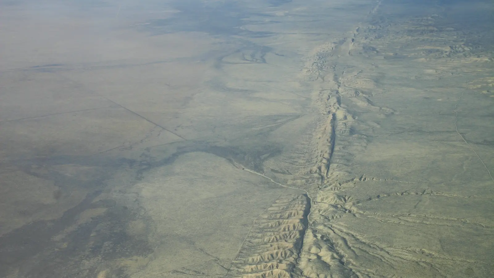
At transform boundaries, plates slide past one another. Friction locks segments until accumulated elastic strain is released in earthquakes.
How scientists know: Fault offsets, earthquake focal mechanisms and geodetic motion show horizontal plate displacement.
What it does—and does not—mean: Plates do not glide without resistance; boundaries can remain locked for decades or centuries.
Independent methods strengthen this part of the story. When laboratory measurements, field observations and quantitative models converge on transform faults accommodate sideways motion, the conclusion becomes less dependent on any one instrument or assumption.
Continents collide instead of easily sinking
Continental crust is thick and buoyant. When an ocean closes, continents may collide, shortening and thickening crust to build mountain belts such as the Himalaya.
How scientists know: Seismic imaging, GPS shortening, folded rocks, metamorphism and marine fossils at altitude document collision.
What it does—and does not—mean: Mountains are not static piles. Erosion, faulting and uplift continue to reshape them.
Uncertainty here is informative rather than embarrassing. Scientists can be confident about the central mechanism of continents collide instead of easily sinking while continuing to refine its limits, history and relative importance.
Rifting begins a new ocean cycle
Continental extension thins crust, forms fault-bounded basins and can eventually allow seafloor spreading. The East African Rift provides an active example at an early stage.
How scientists know: GPS, earthquakes, volcanism and basin geometry measure ongoing extension.
What it does—and does not—mean: Not every rift becomes an ocean; extension may stop or shift.
A careful headline should preserve that distinction: the evidence supports a defined claim about rifting begins a new ocean cycle, not every broader interpretation that can be attached to it.
Hotspots add a different record
Volcanic chains such as Hawaii can form as a plate moves over a long-lived region of mantle upwelling or melting. Age progression records relative motion.
How scientists know: Radiometric ages, geochemistry and plate reconstructions compare hotspot tracks through time.
What it does—and does not—mean: Hotspots are not all perfectly fixed, and they do not replace plate-boundary explanations.
The useful question is not whether hotspots add a different record sounds remarkable, but what observation would distinguish the proposed mechanism from its alternatives. That keeps explanation tied to evidence rather than analogy.
Earthquakes map plate boundaries
Most earthquakes cluster along ridges, transforms and subduction zones. Their depths and fault motions reveal whether plates separate, converge or slide.
How scientists know: Seismometer networks locate events and calculate focal mechanisms from wave arrivals.
What it does—and does not—mean: Earthquake maps outline boundaries but do not predict the exact time of the next large event.
Earthquakes map plate boundaries also illustrates why scale and context matter. A mechanism demonstrated in one species, location or instrument cannot be transferred automatically to every case; researchers test where it applies and where it fails.
Volcanoes follow several tectonic settings
Arc volcanoes rise above subduction zones; basaltic volcanism accompanies many rifts and ridges; intraplate volcanoes can mark hotspots.
How scientists know: Rock chemistry, seismicity and geometry connect magma generation to tectonic context.
What it does—and does not—mean: Not every volcano lies on a plate edge, and not every boundary produces volcanoes.
Independent methods strengthen this part of the story. When laboratory measurements, field observations and quantitative models converge on volcanoes follow several tectonic settings, the conclusion becomes less dependent on any one instrument or assumption.
GPS makes continental motion visible
Permanent stations receive satellite signals and reveal precise changes in position. Vectors across a region show plate motion, strain accumulation and post-earthquake adjustment.
How scientists know: Years of repeated measurements distinguish steady trends from seasonal water loading and instrument noise.
What it does—and does not—mean: A few centimeters per year is slow to people but sufficient to rearrange oceans over millions of years.
Uncertainty here is informative rather than embarrassing. Scientists can be confident about the central mechanism of gps makes continental motion visible while continuing to refine its limits, history and relative importance.
Seismic tomography images the interior
Earthquake waves speed up, slow down and bend through different temperatures and compositions. Tomographic inversions create three-dimensional models of mantle structure.
How scientists know: Multiple wave paths and datasets reveal descending slabs and broad low-velocity regions consistent with warmer material.
What it does—and does not—mean: Tomography resembles a medical scan mathematically, but resolution is uneven and colors are interpreted anomalies, not photographs.
A careful headline should preserve that distinction: the evidence supports a defined claim about seismic tomography images the interior, not every broader interpretation that can be attached to it.
Plate tectonics recycles carbon and water
Sediments and altered oceanic crust carry volatile compounds into subduction zones. Volcanoes return some material to the surface; weathering and burial operate across long timescales.
How scientists know: Rock chemistry, gas measurements and isotope systems trace reservoirs and transfers.
What it does—and does not—mean: Tectonics influences climate over geological time without explaining every short-term climate change.
The useful question is not whether plate tectonics recycles carbon and water sounds remarkable, but what observation would distinguish the proposed mechanism from its alternatives. That keeps explanation tied to evidence rather than analogy.
Supercontinents assemble and break apart
Pangaea was one episode in a longer cycle of continental collision and rifting. Earlier configurations are reconstructed from matching geology, fossils and paleomagnetism.
How scientists know: Apparent polar-wander paths, mountain belts and dated rocks allow quantitative plate reconstructions.
What it does—and does not—mean: Uncertainty increases farther back because ocean floors and many boundaries have been recycled.
Supercontinents assemble and break apart also illustrates why scale and context matter. A mechanism demonstrated in one species, location or instrument cannot be transferred automatically to every case; researchers test where it applies and where it fails.
Landscapes record competition
Tectonic uplift creates relief while rivers, glaciers, landslides and waves remove it. The visible surface reflects both construction and erosion.
How scientists know: Thermochronology estimates when rocks cooled during exhumation; sediment basins record material removed from mountains.
What it does—and does not—mean: A high mountain does not measure uplift alone, because erosion and crustal strength matter.
Independent methods strengthen this part of the story. When laboratory measurements, field observations and quantitative models converge on landscapes record competition, the conclusion becomes less dependent on any one instrument or assumption.
Hazards follow geology, not borders
Plate boundaries concentrate earthquake, tsunami and volcanic hazards, but risk depends on buildings, warning, exposure and preparedness.
How scientists know: Hazard maps combine fault history, ground motion, coastal geometry and population data.
What it does—and does not—mean: Tectonics describes physical likelihood; it does not make disasters unavoidable or equally damaging.
Uncertainty here is informative rather than embarrassing. Scientists can be confident about the central mechanism of hazards follow geology, not borders while continuing to refine its limits, history and relative importance.
The theory remains testable
Modern plate tectonics predicts measurable motions, boundary deformation, seafloor ages, earthquake mechanisms and rock histories. New observations refine plate boundaries and mantle coupling.
How scientists know: Predictions are compared with GPS, seismology, ocean drilling, geochemistry and numerical models.
What it does—and does not—mean: A successful framework is not finished knowledge. Debates continue about initiation, deep mantle flow and regional details.
A careful headline should preserve that distinction: the evidence supports a defined claim about the theory remains testable, not every broader interpretation that can be attached to it.
The three main boundary families
| Boundary | Relative motion | Common results |
|---|---|---|
| Divergent | Plates move apart | Ridges, rifts, new oceanic crust |
| Convergent | Plates move together | Subduction, trenches, arcs or collision mountains |
| Transform | Plates slide laterally | Strike-slip faults and earthquakes |
A planet continually remade
Plate tectonics does not mean that every landscape changes visibly within a lifetime. It means that slow motion, integrated over immense time, rebuilds the geography of the planet. A fingernail-scale annual displacement can move a continent thousands of kilometers. A trench can consume an ocean floor while a ridge manufactures its replacement elsewhere.
The theory’s greatest achievement is connection. The age of seafloor, location of deep earthquakes, chemistry of volcanic arcs, alignment of mountains and vectors from satellites become parts of one account. Important questions remain—especially how plate tectonics began and how surface plates couple to deep mantle circulation—but refinement is not weakness. It is what a mature, measurable theory looks like on a restless Earth.
That motion also links places that appear unrelated today. Sand eroded from a rising mountain can accumulate in a basin, become rock, enter a collision zone and later emerge in a new range. Ocean sediments can be carried into a trench, transformed under pressure and exposed millions of years later. Plate tectonics is therefore not only a map of boundaries; it is a framework for reading the long journeys recorded inside rocks.
Future observations will sharpen that framework. Denser satellite networks can resolve strain within plate interiors, ocean-bottom instruments can illuminate poorly monitored boundaries, and improved mineral physics can connect seismic images to temperature and composition. These measurements may revise regional details or deep-mantle interpretations. They are unlikely to return geology to a fixed-Earth model because the motions, ages and boundary processes are now observed directly.
How scientists reconstruct a vanished ocean
Oceanic plates are continually recycled, so much of an ancient ocean can disappear. Geologists look for fragments left behind: slices of oceanic crust called ophiolites, deep-water sediments caught in mountain belts, volcanic arcs, metamorphic rocks formed under high pressure and magnetic directions locked into minerals. Each clue supplies part of the former geometry.
Dates turn those clues into a sequence. Zircon crystals may constrain when magma formed; fossils date sediments; cooling ages record uplift and erosion. Plate-reconstruction software tests whether proposed continents and boundaries can move without impossible overlaps. Farther into the past, uncertainty widens, so maps should show alternative configurations rather than one falsely exact animation.
Why plate motion is not earthquake prediction
GPS can measure strain accumulating across a locked fault, and paleoseismology can reveal earlier ruptures. Those observations support long-term probabilities and building standards. They do not provide a reliable clock for the exact day, location and size of the next earthquake. Faults interact, friction varies and the decisive nucleation process occurs beyond direct observation.
This distinction protects the value of hazard science. Communities do not need a perfect countdown to reduce risk. Engineers can strengthen structures, planners can map unstable ground and coastlines, and warning systems can act after rupture begins. Plate tectonics explains where hazards concentrate; preparedness determines how physical events become human disasters.
Sources and further reading
- USGS, This Dynamic Earth: The Story of Plate Tectonics
- NOAA Ocean Exploration, Plate Tectonics
- DeMets et al. (2010), Geologically current plate motions
- Seton et al. (2020), A global data set of present-day oceanic crustal age
- Stern (2002), Subduction zones
- EarthScope Consortium, Plate Boundary Observatory
How Barnakle selects and verifies sources · Corrections and updates
Keep exploring.
One remarkable idea at a time—nature, science, history and beyond.
Last reviewed September 15, 2026.

Barnakle Editorial Team
A member of the Barnakle editorial team, exploring remarkable ideas with clarity, curiosity and care.
More from this author →