
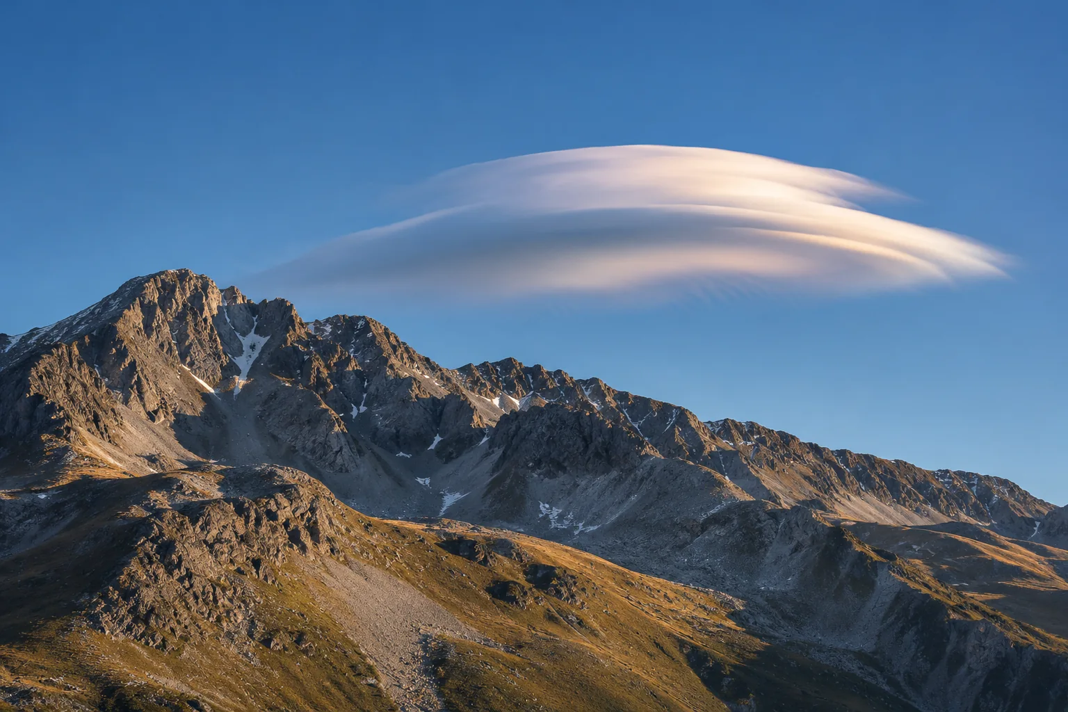
On a windy afternoon, scraps of cloud can race past a mountain while a smooth white lens seems parked above the ridge. The lens stays there because air keeps cooling enough to form cloud in the same patch of sky. Wind carries the droplets onward, and they evaporate where the air descends and warms. The outline can hold its position long after the droplets you first saw have disappeared. A mountain supplies the fixed obstacle that makes this balancing act possible. [1, 2]
Follow a parcel of air over the ridge
Start on the windward side. Air approaching a long ridge may have to climb to get across it. The air pressure around a rising parcel falls. The parcel expands and cools, even if there is little time for it to exchange heat with its surroundings. On the far side of the ridge the flow can descend, then rise again. Under suitable conditions the disturbance takes the form of a wave that extends downwind of the mountain. [2, 3]
Stability matters here. In a stable layer, air displaced upward tends to find itself cooler and denser than the air surrounding it at the new height. Gravity then helps draw it downward. Momentum may carry it past its balance level, setting up another swing. Wind blowing across the ridge keeps feeding air into the disturbance. That combination can sustain a pattern of crests and troughs in roughly fixed positions relative to the terrain. Air still moves through the pattern, much as river water moves through the standing ripple behind a submerged rock. [2, 3]
Where the smooth white edge comes from
The air contains water vapour, which is invisible. As the air cools on the rising part of the wave, it can reach saturation. Tiny droplets then form and scatter light. The place where enough droplets become visible marks one edge of the cloud. After the air crosses the crest and starts to descend, warming allows the droplets to evaporate. On that side the cloud tapers away. At sufficiently cold levels a wave cloud can also contain ice. [1, 3]
To picture the lens in profile, trace one path just high enough to reach saturation near the crest. That path has a short cloudy stretch. A neighbouring path in a moister part of the layer may remain cloudy for longer. Together the many paths can outline a deep middle and thinning edges. The smooth outline is a clue to organized flow at that level. From the ground you see where the droplets scatter enough light to stand out against the sky, so the visible edge need not coincide with the exact beginning of the rising motion. [1, 3]
Why one mountain can seem to have several hats
Sometimes the striking feature is a stack of thin lenses with clear sky between them. Moisture can vary with altitude. If two layers become saturated as they rise but the intervening air stays too dry, both can produce cloud at the same wave crest. The dry layer leaves a visible gap. A photograph taken edge-on can make the layers look almost like a stack of plates. [1, 4]
A row of clouds stretching away from the ridge tells a different story from a vertical stack. Air in a single moist layer may rise to saturation more than once as it crosses successive wave crests downwind. Each crest can carry its own cloud, separated from the next by clearer air in the trough. Rotate the view in your mind. From the side you might count levels in a stack. From overhead you might instead see several long bands, each following a different crest. Both arrangements can occur in a landscape that has only one main ridge. [2, 3]
A cloud caught over Antarctic ice
On December 29, 2020, Landsat 8 photographed smooth clouds over the Eisenhower Range in Antarctica. In ordinary visible light, white cloud on white ice can be difficult to distinguish. NASA’s Earth Observatory showed how infrared information helped bring out the difference. The clouds also cast rounded shadows on the ground. Seen alongside the terrain, those clues helped identify objects aloft in a scene that might otherwise look like a continuous expanse of snow. [5]
A single satellite image records shape and location. To watch a cloud hold its place requires a sequence. Imagine fixing a camera on the corner of a ridge and comparing frames several minutes apart. The outline could expand on one side and fade on the other while its centre stayed over the same notch. It might also disappear entirely without sliding out of frame. Drier air arriving at the crest could erase the visible cloud while the wave continued. Changes in wind can also shift the wave itself, so a cloud that once held steady may move or break up. [1, 2]
What the view from the valley can tell you
A hillside observer can reasonably infer organized ascent somewhere around a well-defined lens. The same observer sees only the parts of the flow made visible by moisture. Clear air between the ridge and the first lens may already be rising or falling rapidly. Nor does a smooth cloud top establish that the air underneath is equally smooth. Mountain waves can be accompanied by rough, rotating flow lower down on the lee side. Weather services distinguish that lower rotor region from the streamlined cloud near a crest. [2, 4]
There is a simple way to keep track of the apparent contradiction. Choose a point on the skyline and ask whether the cloud edge changes position relative to it. Then choose a parcel of wind and ask what happens to its water as it travels. The skyline measures the position of the wave. The parcel undergoes expansion, condensation, descent and evaporation in turn. One view explains why the lens stays in a photograph. The other explains how new material keeps arriving to make it visible.
Keep exploring
Cloud droplets can stay aloft in many settings. For two other views, follow the forces on a droplet and then bring condensation down to ground level.
Sources and further reading
These meteorological resources describe the wave, the visible cloud and the conditions beneath it. The satellite account provides a dated example over Antarctica.
- MetService New Zealand — Altocumulus lenticularis
- UK Met Office — Lee waves
- US National Weather Service, Albuquerque — Standing lenticular clouds
- University of British Columbia — Lenticular clouds and mountain-wave flow
- NASA Earth Observatory — Curious Clouds in the Transantarctic Mountains
Keep exploring.
One remarkable idea at a time—nature, science, history and beyond.
Last updated November 18, 2026.

Barnakle Editorial Team
Barnakle Editorial Team is the collective byline used for Barnakle’s editorial articles. The contributor profile explains the team identity and links to the publication’s editorial policies.
More from the editorial team →