
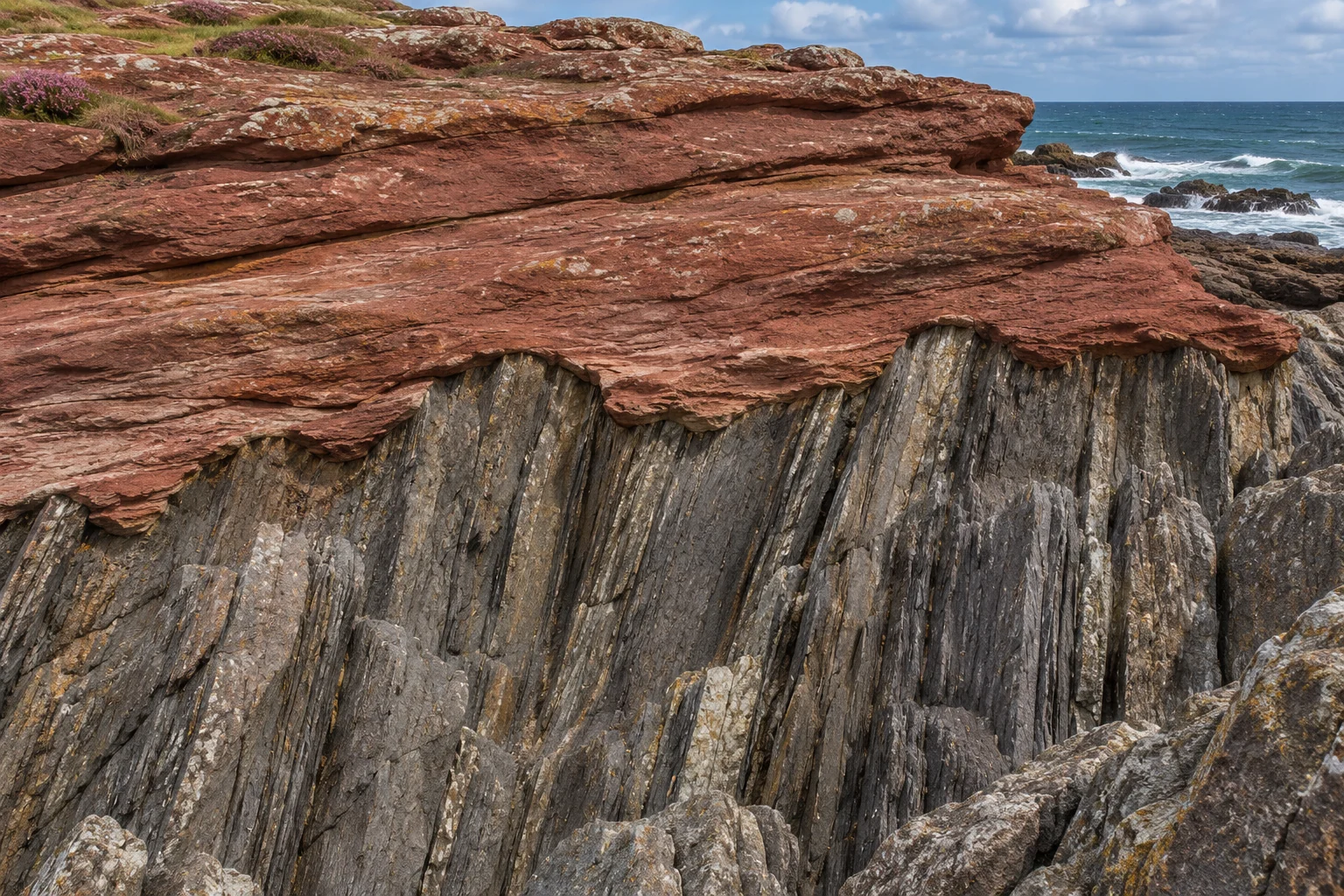
At Siccar Point on Scotland’s southeast coast, dark bands of rock stand almost on end. Follow one upwards and it stops against a bed of reddish rock that slopes only gently. The next dark band ends there too. The part that caught James Hutton’s attention was this junction. The older beds had acquired their steep tilt and had been cut across before the younger sediment came to rest on them. Two pieces of rock that touch today are separated in age by roughly sixty million years.[1, 2]
Geologists call such a contact an angular unconformity. The angle is visible, but the time interval itself occupies no measurable thickness. You could put a finger across the boundary. What gives the gap away is the sequence of events needed to put the two sets of beds into their present arrangement. Reconstructing that sequence and assigning dates to it are separate tasks. Hutton and his companions could do much of the first in 1788 without the numerical ages geologists use now.[1, 2, 4]
Follow a single bed to its end
A patch of Scottish shoreline is full of cracks, ledges and shadows that can look like layers. Begin with a band you can recognize by what it contains. At Siccar Point the older succession includes beds of hard grey sandstone alternating with finer mudstone. Trace the boundary of one sandstone bed sideways. Nearby beds follow much the same steep orientation. Now trace them towards the base of the reddish material. Successive beds terminate against the contact instead of bending smoothly into the upper layers.[1, 3]
That repeated cutting-off of layers is called truncation. Imagine painting parallel stripes on a board, tilting the board upright and sawing across its upper corner. Each stripe stops at a different place along the cut. Lay another striped board across the cut and its stripes follow a new direction. This little model captures one relationship in the rock. It says nothing about what did the cutting, how long the cut was exposed, or whether the surface was as flat as a saw would leave it. Those are questions for the outcrop.[1, 3]
The old land surface was uneven
The surface below the younger beds is irregular in considerable detail. Some hard sandstone beds stood up above neighbouring material as erosion worked across the older rocks. Younger deposits accumulated in depressions and overlapped the sides of those projections. A coarse deposit at the base of the younger succession is thick in some places and absent in others. A drawing made with a ruler across the contact might correctly record the change of angle while losing evidence of the shape of the ancient ground.[1, 3]
That shape helps distinguish this junction from a fault. A fault can bring strikingly different rocks together by movement along a break. A difference in angle across a sharp boundary is consequently an invitation to investigate, rather than proof by itself. At Siccar Point there is a depositional relationship to explain. Younger sediment fills hollows and extends over the truncated edges of older beds. Those observations let a geologist reconstruct where the new sediment settled, even though later events have tilted the younger beds a little too.[1, 3]
Read the events in order
The earliest part of the story preserved here involves sand and mud accumulating in an ancient sea during the Silurian Period. Successive deposits became rock. Mountain building folded and steepened the beds. Erosion then removed enough overlying material to expose their cut ends at the surface. By the Late Devonian, new deposits accumulated on land above that surface. The red sandstones and conglomerates belong to a different environment from the marine beds below. Much later erosion on today’s coast made the contact visible in section.[1, 2, 4]
There is an asymmetry in how much of each episode the eye can see. Thicknesses of sandstone remain from deposition. The inclination of the beds and folds records deformation. Erosion, however, removed part of its own evidence along with the rock it carried away. Nobody can recover a complete list of vanished beds just by counting the visible stubs. The younger beds preserve the surface that happened to exist when burial resumed. Whatever lay above that surface beforehand is the missing part of this local record.[1, 3, 5]
Where does sixty million years come from?
The Geological Society of Glasgow gives approximate ages of 435 million years for the older beds and 375 million for the younger ones. Subtraction puts the separation at around sixty million years. It would be a mistake to divide that number by the height of the grey ridge and call the result an erosion rate. The interval includes changes in the older rocks, exposure, erosion and possible periods when little sediment accumulated. The height of a single surviving ridge does not measure all of the material removed.[2, 3]
The distinction becomes clearer if you compare two points along the same contact. At one, younger sediment may fill a deep hollow. At the other it may just cap a high projection. Two observers could report very different thicknesses for the lowest red deposit and still be describing the same interrupted sequence. The numerical dates belong to the surrounding rocks. Evidence for a vanished landscape comes from walking the junction sideways and observing how those rocks meet in different places.[1, 3]
Missing here can mean preserved somewhere else
The National Park Service describes several gaps in the much longer rock record exposed at Grand Canyon. Different older units can lie beneath the younger package in different parts of the canyon, changing the amount of time missing at that place. The principle applies just as well to a Scottish point of land. While erosion strips sediment from one site, material can accumulate at another. An unconformity is a gap in the surviving record at a location, not a time during which geological processes stopped.[4, 5]
In 1788 Hutton, John Playfair and James Hall approached Siccar Point by boat. They could see the ends of one landscape buried underneath another without knowing the dates of either. The contact still offers that exercise to anyone looking at a clear photograph. Follow several dark bands to the red rock. Ask which events had to happen before the first red sediment could settle there. The time is invisible, but the order that requires it is written across the shore.[2, 4]
Related reading
Sources
- International Union of Geological Sciences — Siccar Point, Hutton’s Unconformity
- Geological Society of Glasgow — Siccar Point
- Joint Nature Conservation Committee — The Old Red Sandstone of Great Britain, Chapter 3
- Scottish Geology Trust — Siccar Point
- US National Park Service — Missing time at Grand Canyon National Park
Keep exploring.
One remarkable idea at a time—nature, science, history and beyond.
Last updated November 21, 2026.

Barnakle Editorial Team
Barnakle Editorial Team is the collective byline used for Barnakle’s editorial articles. The contributor profile explains the team identity and links to the publication’s editorial policies.
More from the editorial team →