
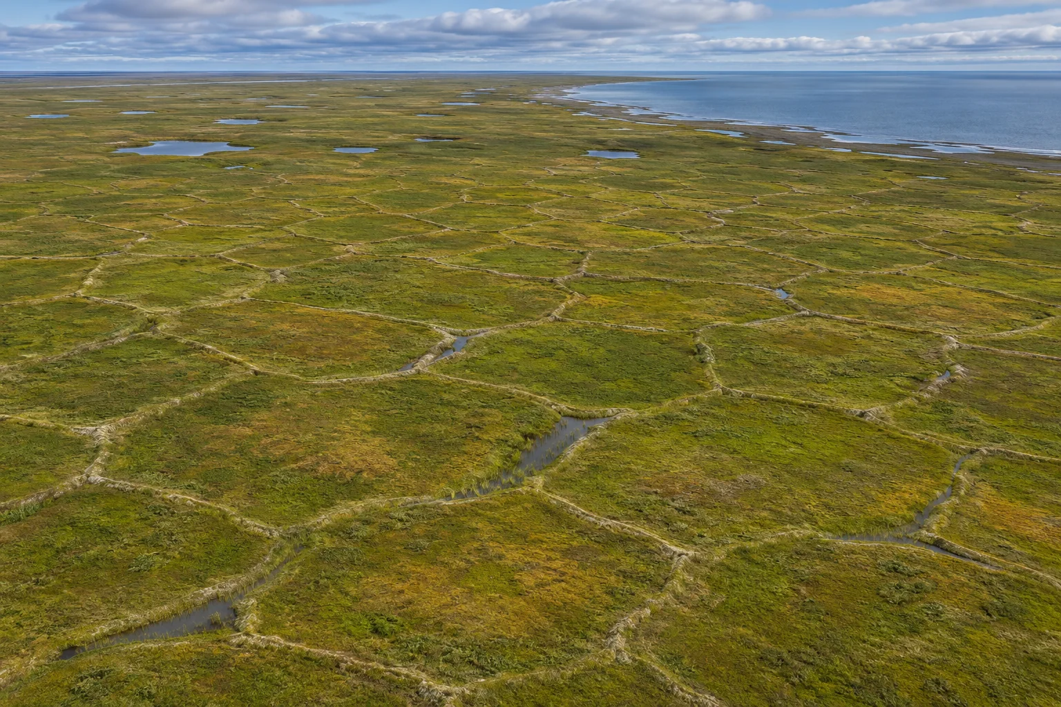
From above, some stretches of Arctic tundra look as though someone has drawn property lines across the marsh. Narrow strips of grass or dark water run straight for a while, meet other strips, then turn sharply. The boundaries continue across land with no fences and no fields. A good place to look for their origin is straight down, beneath one of the lines.
Much of this patterned ground traces a network of ice wedges. A cold winter can split frozen ground as it contracts. Water enters the fracture and freezes. If cracks reopen near the same places over many winters, thin additions of ice can build a substantial wedge. The polygon on the map is the patch of ground between several wedges. Its outline is the visible part of a structure that extends below the reach of summer warmth.[1, 2]
A winter crack can outlast the winter
Soil does not need to dry out to crack. When the surface of frozen ground cools sharply, it tends to contract. Neighbouring material resists its movement, allowing tension to build. A fracture relieves some of that tension. Because one break cannot relieve the stress across a whole plain, others form elsewhere. Where the lines meet, they divide the surface into roughly polygonal pieces. The number of sides varies, as does the angle between adjoining cracks.[2, 3]
Spring meltwater supplies a useful part of the story. Water that finds a route down a crack can reach ground cold enough to freeze it. In summer, the layer nearest the surface thaws. Deeper down, ice can survive in permafrost, ground whose temperature remains at or below freezing for at least two consecutive years. Think of a mark on a page whose upper edge is rubbed out each summer. Enough of the line remains below for it to influence what happens the following winter.[1, 2]
In a later cold spell a fracture can reopen along that weakened zone. A new sliver of ice may be added beside the earlier one. The buried mass can grow wider near the top and taper downward. An exposed bank seen from the side might show a wedge cutting into the soil. A photograph taken from above can show a line crossing the tundra. Those are two views of the same feature, as different as a slice through a loaf and a view along its crust.[2, 3]
Why some polygons have square corners
An attractive explanation for a regular-looking pattern is that every patch was free to shrink in the same way. Actual terrain has a history. In the Old Crow Flats of Yukon, researchers describe networks around lakes and drained lake basins with many nearly right-angle intersections. A lake can change how nearby ground cools. An existing boundary can favour cracks in one direction, after which later cracks can meet them across that direction.[3]
Try sketching those two sequences. In the first, scatter a handful of short lines on a blank page and extend them until they meet. In the second, draw an old shoreline first and arrange several lines perpendicular to it. Even before adding the later cracks, the second drawing has a direction the first lacks. That is why the orientation of many polygons together can tell a geologist something that counting the sides of one polygon cannot. A right angle on its own is a poor guide to a landscape’s past.
Follow the water around the rim
A low-centred polygon has a middle that sits below its margins. In a small patch of tundra, even a modest ridge can keep water from moving into the next patch. One centre might hold a shallow pool while the rim supports a different strip of vegetation. A person looking across at grass height could easily miss the full shape. From overhead, scores of shallow basins repeat the same arrangement.[4]
Now picture ice near the top of a wedge melting. Soil above it can settle into the space, creating a trough along what used to be the boundary. Water may collect in the trough while the centre stands relatively high. A photograph of a dark ring around a lighter patch can therefore tell a different story from a photograph with water pooled in the middle. The distinction comes down to a few changes in relative height. Both images could have been taken in summer.[4, 5]
The next change can sound contradictory. Thaw can produce ponds in one place and improve drainage a little later. A short trough with high ground at either end holds water. Join it to other troughs and give the network an outlet, and water has a path away. In a pan-Arctic study, Anna Liljedahl and colleagues examined how degradation of ice wedges rearranges drainage. In estimating what a wetland will do, where the channels connect can matter as much as the area they cover.[5]
What an aerial photograph can tell you
In Alaska’s Arctic national parks, researchers compared images from different years and looked at where standing water lay relative to the polygons. Weather and seasonal timing can change how much water is visible on any one date. A summer photograph can reveal an elongated pond over a wedge or a pool at the junction of several troughs. More observations are needed to tell whether a new connection persists, and how much ground ice has disappeared beneath it.[4]
In Nunavut, the pattern also mattered to a trail. Work in Kugluk Territorial Park near Kugluktuk brought together information about ice-rich ground and permafrost degradation to help select a route for a boardwalk ATV trail. The surface marks gave researchers and the community a way to read what lay under the route. A firm-looking strip on a summer day and the long-term stability of the ice beneath it are different observations.[1]
If you come across an aerial view of patterned tundra, start with one patch and follow the water. Is it in the middle, along the margins, or leaving through a gap? Then look outward to see whether the same arrangement repeats. Those two questions turn a striking geometric pattern into a map of winter cracks, summer thaw and the routes water can take today.
Keep exploring
Buried glacier ice can leave a round lake behind, while ice cores preserve a different record of past conditions.
Sources and further reading
- Polar Knowledge Canada — Permafrost and trail planning in Kugluk Territorial Park
- U.S. Geological Survey — Permafrost and periglacial environments
- Roy-Léveillée and Burn — Thermokarst lakes and ice-wedge polygons of Old Crow Flats
- National Park Service — Stability of ice wedges in Alaska’s Arctic national parks, 1951–2019
- Liljedahl and colleagues, Nature Geoscience — Ice-wedge degradation and tundra hydrology
Keep exploring.
One remarkable idea at a time—nature, science, history and beyond.
Last updated November 20, 2026.

Barnakle Editorial Team
Barnakle Editorial Team is the collective byline used for Barnakle’s editorial articles. The contributor profile explains the team identity and links to the publication’s editorial policies.
More from the editorial team →