
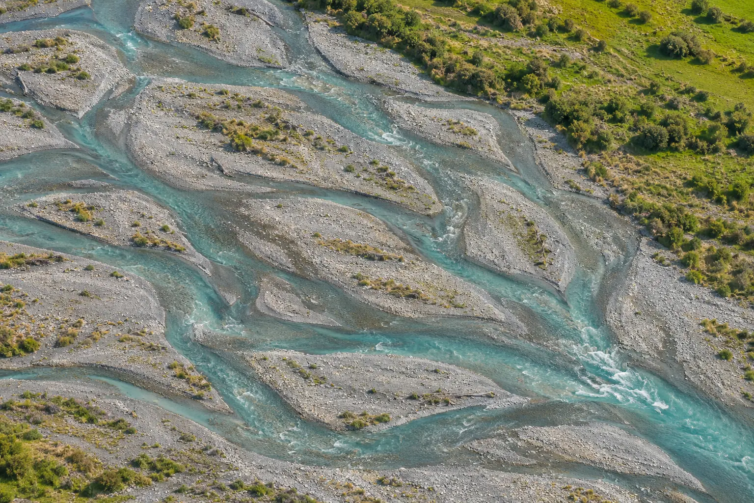
From the air, a braided river looks like several rivers trying to share one valley. Follow a single blue thread downstream and it divides around a gravel bar, joins water from another channel and divides again. The bars are the clue. The river transports sediment, deposits some of it on the bed and then takes new routes around the deposits. Where water can erode the banks and rearrange the bed across a broad corridor, those repeated splits and reunions give the river its braided pattern. [1, 2]
A gravel bar changes where the water goes
Consider a reach carrying pebbles as well as water. The water can continue downstream while some of the heavier particles settle in a patch where the local flow can no longer keep them moving. A small deposit on the bed makes the water shallower immediately above it. As more water finds its way around the sides, the routes on either side can deepen. Material deposited on part of the bar can also be eroded and carried farther on. A bar can grow or shift even though the individual stones making it up keep changing. [1, 2]
Whether those changes produce lasting multiple channels depends on the surroundings. Banks made of readily eroded material can retreat as a channel swings against them. A wide valley floor gives the river room to develop new paths. Abundant sediment supplies the bars around which water can divide. The slope and the amount of water passing through influence how much material the reach can move. A single gravel pile in a narrow, confined stream does not automatically turn the whole stream into a braided river. [1, 2]
A helpful way to read an aerial view is to follow the water around just one bar. At its upstream end a channel divides. Farther on, the two threads can carry quite different amounts of water before meeting again. Nothing requires the split to be even. A deeper path may carry a large share past one bank while a shallow trickle skirts the other. A uniform blue line on a simplified map can hide that important difference in width and depth.
Why the view changes after high water
A braided river seen at low water often has a great expanse of bare gravel exposed between channels. At higher water some of those bars disappear under the surface. Two changes can be happening at the same time. The rise can simply cover a bar that is still in roughly the same place. A stronger current can also move some of its sediment and cut a channel where there was little flow before. When the water falls, the exposed pattern can be quite different from the one that went under. [1, 3]
Picture a camera on a fixed bluff taking photographs before, during and after a flood. In the middle photograph a gravel island may seem to have vanished. To tell whether it was eroded away or merely submerged, compare the photographs taken at similar low levels on either side of the flood. A surviving patch of vegetation can help locate the same bar. A new channel cutting across the patch, or a new deposit where deep water previously flowed, is stronger evidence of a change in the bed itself. [3]
This is also why asking for the number of channels in a braided reach needs a little care. The answer depends on the river level, the part of the reach you choose and the smallest trickle you decide to count. You can measure how many wet channels cross a particular survey line on a particular day. The broader question is whether splitting and rejoining around mobile bars characterizes the reach over time. A single count and a long-term description answer different questions. [1, 4]
Finding yesterday’s channels beside today’s Snake River
In Wyoming’s Grand Teton National Park, the Snake River provides an example downstream of Jackson Lake Dam. Spring and early summer snowmelt increases flow, and high water can cover bars and carry sediment. As the flow subsides, lower surfaces remain wet and others emerge. Some channels persist for years, as do some islands on which vegetation establishes. A braided river can have enduring features within an arrangement that changes continually. [3]
The park used laser elevation measurements to show subtle features beside the water. An ordinary elevation map of a long river tends to emphasize the overall fall downstream. A relative elevation model instead expresses nearby ground height in relation to the river level along that reach. Low swales and former flow paths can then stand out against slightly higher ground. A visitor at one point on the bank sees today’s waterline. The elevation pattern records a wider area across which water has moved. [3]
A gravel bed can look empty while supporting a community
In Canterbury, New Zealand, the braidplain includes bare gravel as well as shallow channels, islands, ponds and other wet or dry surfaces. Environment Canterbury describes how this changing mixture supports native wildlife, including birds that use open gravel for nesting. A surface with little vegetation can be valuable habitat precisely because repeated flooding and deposition help keep it open. To an observer looking only at the deepest channel, a large part of the river’s ecological footprint would appear to be missing. [4]
There is a distinction between this kind of split and the branching seen at the mouth of a delta. Delta channels can distribute water and sediment along different routes into a lake or sea. In a braided reach, neighbouring threads repeatedly split and meet again within the river corridor. A river can have both patterns along its course. To interpret a map, follow each thread far enough to see whether it returns to the others or carries part of the flow to a separate outlet. [1, 2]
The best question to take back to the aerial view is where the sediment went. Choose a pale bar, trace the channel that passes it and look downstream for the next widening or deposit. What appears at first to be a complicated arrangement of blue lines begins to look like a record of the material the river has carried, set down and picked up again.
Keep exploring
Follow a single river bend as it turns into an oxbow lake, then compare the channels a river builds where it deposits sediment at its mouth.
Sources and further reading
The field examples come from Wyoming and New Zealand. The channel-pattern study examines how moving water and sediment produce different river forms.
- US National Park Service — Fluvial features of a braided stream
- Leopold and Wolman, US Geological Survey — River channel patterns, braided, meandering, and straight
- Grand Teton National Park — Tracing the braids of the Snake River with relative elevation models
- Environment Canterbury — Importance of braided rivers
Keep exploring.
One remarkable idea at a time—nature, science, history and beyond.
Last updated November 18, 2026.

Barnakle Editorial Team
Barnakle Editorial Team is the collective byline used for Barnakle’s editorial articles. The contributor profile explains the team identity and links to the publication’s editorial policies.
More from the editorial team →